


The South Island of New Zealand may well be most beautiful to experience on this world trip. We have a month to explore it. And it starts promising. The ferry to Picton is one of the most beautiful crossings in the world due to the Marlborough Sounds, the fjords along the north coast of the South Island. We are on the largest boat in the Interislander fleet, made by Van de Giessen De Noord, well known in the Netherlands. Dutch glory with also a lot of Dutch tourist on board. Later we meet some of the Dutch people at the supermarket in the arrival village of Picton.
We need water and the woman at the visitor center claims that there are heaps of fontains on our way out to fill our water bottle; with the bottle in our hand we jump on our bikes, but when we cycle out of the village we have not come across any water point. There is nothing else to do than go back and buy water at the supermarket, meet the other Dutchies, have a nice chat, but we hate it to cycling back and we hate to buy plastic bottles of water if tap water is drinkable.

Marlborough Sounds
We want to cycle to Nelson in a day and a half. Nelson is the first city of any significance on the South Island. Our aim for the afternoon after the ferry is a campsite at Pelorus Bridge, 55 kilometers away. Immediately after Picton we have to climb. This afternoon we cycle along the Marlborough Sounds on Charlotte Drive, a winding road with dozens of beautiful views where no freight traffic or large buses are allowed and where the maximum speed is set at 50, so also not interesting for speed devils. It is wonderfully quiet and, contrary to forecast, the weather is pretty good. Only the last stretch of 20 kilometers - we just did the second significant climb - the weather turns. Dark clouds ahead of us do not predict anything good, while we just cycle through a sympathetic village called Havelock. When we cycle out of the town we hit the brakes and dub: if we continue cycling, it will probably be in pouring rain and we will never get warm again at the campsite, but if we stay here in Havelock, only a few drops might fall while we sit warm and dry in a cheap motel. "When in doubt, don't" is a proven criterion when it comes to so-called shortcuts. We are deploying it to this situation and choose to stay in a cheap motel in Havelock. Completely underexposed in these considerations is that tomorrow it will rain a lot anyway and that cycling fewer kilometers today means, that we need to cover these kilometers in the rain tomorrow morning.
In the supermarket we meet Frank from Germany. He gave us a thumb up earlier when we thought we were just passing through the village. He tells us he's also traveling by bike and has 22 days to cycle down the west coast. He has booked all accommodations in advance and will cycle to Nelson tomorrow. That is also our goal, but in view of the predicted rain: he must (given the bookings in advance) and we can (enough time and nothing booked). When we walk back to the motel some raindrops fall: yes, we made a good decision to stay here! Afterwards it indeed is only these few drips.
The next morning starts dry, but exactly according to the weather forecast it starts to rain from 9 o'clock. The weather forecast indicates that it'll be dry again later in the afternoon and that even the sun will break through. This gives the cyclist courage as he / she deepens the rain gear from the lower regions of the panniers. We'll dry up later today, right? We have a head wind and the rain is bizarre cold. For a long time we cycle behind Frank who apparently left Havelock just a few minutes earlier than us. The first opportunity to hide is at that campsite 20 kilometers from Havelock, at the Pelorus Bridge. There is a coffee shop there and it is full of ... Dutch people. There they are again! Not the same people as yesterday, but it's nice to answer the many questions that are fired at us. Our sympathetic neighbor, Frank, is also there and the three of us decide to sit out the worst rain while enjoying coffee, a roof over our heads and the chats. It's after noon when we get back on the saddle and start two more steep climbs over 60 kilometers. During the second serious climb we suffer a big cold shower again but then the predicted sun really breaks through.

on the way to Nelson
In Nelson we end up enjoying the warmth of the sun on a terrace of a brewery in a converted old church (but we do wear our warm downjackets). After this moment of enjoyment we cycle on a former train trail to Stoke, a district of Nelson and home of Andy, our Warmshowers host who hopefully can give us some advice again about the route on the South Island. The originally British Andy has cycled a lot but as it turns out not on the South Island. He wants to next February. So we have little help on his advice, but are grateful for the warm shower, the vegan lasagne and a nice bed.
The next morning we use Andy's garage to check and grease the bikes. Andy once worked at a bicycle shop and has a great collection of bicycles and tools. He also cycles along to show us the shortest route. By the way, he doesn't really cycle with us. Without luggage he races ahead of us. We will only cycle a very short distance today: 25 kilometers and have all the time in the world, but Andy is speeding us up to the max. After about 20 km he says goodbye and we cycle the last few kilometers at our ease to a cottage where a close-knit family of pigs and a group of cows are our next door neighbors. The bulls live a meadow away, apparently they are not happy with the fact that there are no cows walking around in the barbed wire, because they "roar" on it, day and night: it doesn't sound masculine, rather "desperate".
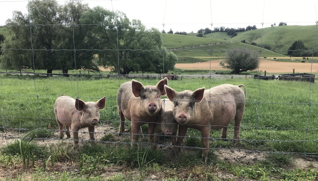
our nice next-door neighbors
We are in an area called Eighty Eight Valley, cycle a route called Golden Downs Trail and that would be quite popular to road cyclists because they can train two climbs out of Nelson and then ride back. We do the climbs on touring bikes with luggage and climb slowly (slowly because we frequently descend pieces again and start the climb again) to Saint Arnaud at about 700 meters above sea level. Saint Arnaud sounds French and we tend to pronounce it in his French, but we hear from the motel owner that the French way would be to posh here and therefore they pronounce it in an English way.
On the way to Saint Arnaud, the sky moved back to the now familiar dark hues and we have had such an ice-cold shower again and many more are coming. Instead of the beautiful campsite on the lake, we did check in at a motel again. These motels don't fit within our budget, but that is a concern for later. For now a hot shower and heating is necessary and a motel offers that. But first we quickly cycle between the showers in the sunshine to the lake: Lake Rotoiti (confusingly the same name as the lake on the North Island near Rotorua, but that aside). The snowy peaks of the mountains around the lake are hardly visible through the low-hanging clouds, but it still gives a beautiful sight. A long time ago in the last ice age, way before climate change, there was a glacier here, says the motel owner. He tells a lot more about the local history and jokes: nice, interesting guy.


on the way to Saint Arnaud

Lake Rotoiti at Saint Arnaud
From Saint Arnaud we take the Rainbow Road: just the two of us for two days on a deserted gravel road, where we need to lift the bicycles over closed gates. Part of the road is washed away and there we have to lift the bike. Part is too steep to cycle and there we have to push the bikes. Part is too steep (> 25%) down and there we have to walk down. Halfway the road is a cabin with bunk beds and (important) heating because at night it'll be well below zero. Or are we not going that way? In the morning it is very cold (-3) and Harry suggests the idea to ignore the Rainbow Road. Why would we allow ourselves that misery if we could also downhill 60 km to the village of Murchison and still keep all route options open. Good idea, Harry! So no Rainbow Road.
The icy cold wind keeps bothering us for the entire 60 kilometers. There is not much wind but in the valley where we push ourselves down it takes on a stormy character. The wind is so cold and that it makes us check in again at a motel. The plan to exchange the cold and windy west coast for the warmer east coast is receiving increasing support in camp Heart to Beat.
That cold slowly disappears from the sky the next day and we cycle a pretty nice route from Murchison to Reefton. For the second day in a row we follow the Buller River valley. The river is quite wild and suitable for rafting and that is offered on parts of the river. We cycle along steep rock faces, often with the clatter of a crashing waterfall or creek. The Buller River goes "straight ahead" to the sea as we turn off to keep cycling more inland. After a quiet back road we turn up to a similarly quiet main road that runs next to a railway line. The main road, just like the railway line, is almost straight and the wind blows in the exact opposite direction and the icy cold may be out of the wind, but the power is certainly not. We struggle against the wind for the last 26 kilometers before we arrive in a seemingly Christian village of Reefton, based on the number of churches and other symbols that we see.

on the way to Murchison
Finally we are back at a campsite and one with a camp kitchen and so it is nice to socialize again with other guests. It is so much more fun to camp in the sun and warmth than to be locked in a motel room in the cold and rain. It is now clear, we are going to the east coast. To get there, there is nothing else to do but to briefly defy the wind, cold and rain of the west coast. The wind, cold and rain apparently took a sickie the next day and of course we have no problem with that at all and it will not change our decision to get to the east. We cycle about 85 kilometers on quiet roads through valleys and alongside wide rivers to Moana, a village on Lake Brunner. It is such a perfect day that we ended up taking an old-fashioned beer on a terrace overlooking the lake.
And as always, all beautiful things eventually come to an end. That end is the next morning when we break up in the rain. It is the day of the crossing to the (hopefully) warm and dry east coast and the first leg leads to the Arthur’s Pass at just above 900 meters. In principle, that stage is quite simple with the exception of the last 7 kilometers with pieces more than 10%, even more than 15% and peaks of 20%. The weather forecast for Arthur’s Pass looks pretty favorable with around 18 degrees and only around 10 o'clock in the morning chance of rain. We sit on the saddle from half past eight and it rains continuously. After 50 kilometers - now fully soaked - and a few close encounters of nasty and / or inattentive drivers who pass us by, we turn to the only coffee shop on the route to dry up and warm up. We are approached twice there. Firstly by a man who offers to drive us to the other side of the pass and secondly by the driver who comes to apologize for driving so close to us. In 99.9% of the cases we would thank Mr. 1 very much for the offer, but because of the continuing rain, the poor visibility and the crazy drivers we take up his offer: yes please! There is an insanely beautiful drive to the top, at least we have heard, because the rain and clouds make it impossible to see anything until we are far beyond Arthur's Pass. Chris and Tanya drive to Christchurch and let us get off wherever we want. The plan was to stop at the top of Arthur's Pass today and camp but it is gray, dull, cold and wet so driving a bit further seems the best option.

By rain and wind to Arthur's Pass
After Arthur's Pass it gets drier and warmer and we get off at the village of Springfield. We are well aware that we have skipped a very beautiful part of New Zealand (the descent and a second pass). What we have seen that the steepest parts to Arthur’s Pass are difficult to cycle safely and the steep parts offer little room if we had to push the bike up. During our journey we sometimes wonder if we come across our guardian angel, or at least the patron saint St. Christoffel: in this case it were Chris and Tanya from Christchurch. What a bunch of beautiful people this world accommodates, when you travel, you will come across them!
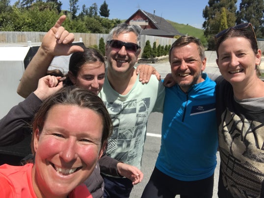
Selfie with Jill, Chris & Tanya

Beautiful weather in Springfield
We pitch the tent in Springfield so that it can dry in the sun and wind, we strip our wet clothes off and take a nice warm shower at a nice warm campsite. From Springfield we cycle in the direction of the central massif of the Southern Alps, with mountain peaks well above 3,000 meters, including Mount Cook, New Zealands highest with 3,750 meters. The way to there leads us through Rakaia Gorge. From Springfield it is not far to cycle, but we like to arrive early and hike in the afternoon. The host of the campsite leads us to a place with a great view of the Rakaia River that has carved a great wide and 150 meter deep gorge. The walk is shortened immediately. Instead of a four-hour hike, we'll settle for a one-and-a-half-hour hike to the first viewpoint and back to our tent to enjoy the amazing view.


Rakaia Gorge
A couple of French cyclists arrive at the end of the afternoon. They say they are on their first cycling holiday and they think they still have a lot to learn. Their tent is too small and they look glorified at our lightweight seats. The next morning they first want to do the four hours long walk and then cycle the same distance as we do to Geraldine. It would be nice to see them again at the end of the day even though we think their day plan is a bit ambitious.
Our day plan brings us after a steep climb out of the gorge on nice quiet backroad that later becomes more boring with flat monotonous straight roads. The wind, which blows us through the beautiful landscape fanatically at the start of the day, has unfortunately fallen away on the straight monotonous parts and we muddle up to the town of Geraldine. The town has some body, vibe and appearance ("historic" buildings !!) and the campsite is located right in the center. The usual cosiness prevails around the camp kitchen. A Dutch woman talks about her cycling adventures and later brings us cheese and speculaas from the Netherlands, a New Zealand man comes in cycling after a multi-day tour “in his own backyard”, two Canadian couples admire our bikes and give us a telephone number in case we visit Montreal, but unfortunately the cycling French couple do not arrive.
There is one last cycling day left in this blog and that is the day from the village of Geraldine to tourist trap Lake Tekapo, also starting point of the Alps to Ocean Cycle Trail, the most famous, most beautiful and often advised of the Great Rides. It is a tough day by first climbing to the village of Fairlie and then a very heavy stretch straight into the raging wind to Tekapo. On that last stretch of 16 kilometers - which takes us two hours and is almost driven off the road by a couple of Asians in a rental car - we decide that it is best to book two nights at the Tekapo campsite. Just a day of rest before we start the utmost finest stretch on all our around the world trip. A wonderful prospect until we see the campground: bare, expensive and overcrowded. Not nice to stay an extra day here. Instead we will directly continue to the most beautiful part of New Zealand! This blog closes with this cliff hanger.

Lake Tekapo