

In this final part of our blogs on cycling the canaries, we have returned to Gran Canaria. From first the west and then the south we move into the interior and high mountains and are surprised how incredibly beautiful this island is.

Day 21 Gran Canaria: Agaete to La Aldea
The day begins with some irritation and especially surprise when we encounter at breakfast a group tour company with about 10 French 50+ hikers, who without mouthguards and without keeping their distance are running crisscross along the buffet, taking bread and croissants by hand from the breakfast buffet (and sometimes even putting them back by hand later). Hello bonjour dear people, ever heard of Corona? We cycled through France this summer and it was a real thing there too. Then we see them supplementing the prepared lunches from the buffet and even taking a spoonful. Ce n'est pas normal.
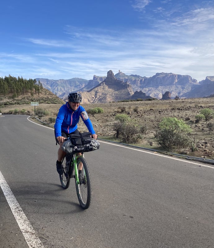
But anyway, we have a different focus today: with over 3000 altitude meters it promises to be the toughest stage of our cycling trip across the Canaries. Along the way we only encounter one hamlet (El Risco) that is supposed to have a bar/cafe, but we don't dare to assume it's open. Moreover, we reach El Risco after only 15 kilometers. So we first go to the Spar Express that is open on Sundays. This Spar sells liters of water and tins of sweet iced tea, but also freshly made baguettes. It is a bit of a puzzle how we can take these extra drinks and provisions with us with our minimal bikepacking set, but with some shifting, especially to the steering wheel, we succeed.
The famous GC-200 starts at the edge of the harbor village with the kilometer sign "0" and immediately forces us to switch to the smallest gear. Having gained quite a bit of altitude, this iconic coastal road shows us a beautiful sight for over 10 kilometers: the road flattens itself along and against the steep coastal slope and follows the contours of the mountains. Practically perpendicular below us, the surf pounds against the coastline. Behind us we have a long view of the harbor and the ferry. In front of us we see the coastline, the surf and the high mountains. It is truly spectacular!
We know that the GC-200 is a dead end. After a rock slide the government has decided to stop fighting and to put the money into the alternative: the highway GC-2 along the east coast is already largely finished and can take over the through traffic. An exception is made for cyclists: they too are allowed to use the highway; a detection system would have been installed to prevent them from being run over in one of the many tunnels. Via the combination GC-200 and GC-2 you can be in La Aldea, our final destination today, after only 30 km. It will take us 70 km with mucho altitude gain.
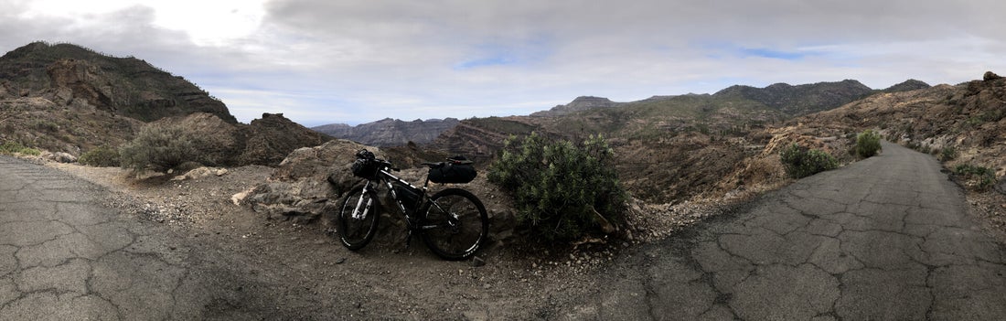
The bar in El Risco is open and we buy a big bottle of water, just to be sure. After the hamlet, the GC-200 rises steeply again with an average gradient of over 10 percent. Soon we come to the point where all traffic turns onto the GC-2 and immediately dives into a tunnel. The GC-200 turns sharply left and up with a sign indicating a dead end. We know that at the point where the GC-200 stops there is a gravel path that dives into the mountains. Hoping that this information is still correct and the gravel path has not also been swept away by a landslide, we begin another steeper section of the GC-200. We now have the road all to ourselves; all other traffic has entered the tunnel, which by now is soon far below us. Finally, there is a guard rail across the road with another fence behind it. As if that were not enough, a couple of signs also make it clear that the GC-200 is really finished here. We look up and to the left and indeed we see a gravel path that immediately winds upwards via a couple of steep hairpin bends. A little over 100 feet up we come across a finca with a couple of angry dogs and with a fence across the gravel path. The fence is securely locked with a chain lock. What the heck? Other than the barkers, there is no living creature to be discovered. Next to the fence we see a narrow passageway through which we wriggle our MTBs and we continue our trip, but now with the feeling that we are cycling over someone's land without permission. In America you can be shot for that. However, this feeling is quickly supplanted by the stunning beauty of the surroundings. How beautiful it is here and we are the only ones enjoying it! We encounter another finca but there too only a barking dog and not a soul in sight. We first descend unexpectedly (we are not that well prepared) 150 meters and then have to climb from something like 550 to 1220 meters. What follows is one of the most beautiful and toughest climbs ever.
Dozens of hairpin bends ensure that we quickly gain height against the various mountain sides and by now the slopes are forested. The trees show that a forest fire raged here a few years ago, but most seem to have survived. Somewhere around the tenth hairpin we encounter the first and only living soul on this path. It turns out to be a cyclist too, an Austrian bikepacker.
He is following the Granguange trail that we wanted to follow in the beginning. How funny, we are on the trail again, unintentionally. And this part is so beautiful that we secretly think that we have missed much more beauty by not following the trail. But the Austrian makes it clear to us that the Granguange is regularly more of a hell than a heaven. We chat for a while and wish each other safe travels when we say goodbye. More than ten hairpin bends follow and a lot of ooohhs and aaahhhs, until we arrive at yet another locked gate. Here too we squeeze past and suddenly find ourselves on asphalt again. It is the GC-216. What first seems to be a "normal" road with a ditto descent soon turns out to be one of the most beautiful. It just doesn't stop today and we already know that this day will be one of the most beautiful stages we have ever ridden. Soon we're at a viewpoint (mirador del Sargento) which makes it clear to us that we're cycling in a uniquely beautiful, rugged mountain landscape. It is indescribably beautiful; we take pictures but know that you can never capture this beauty with your average iPhone. The landscape reminds us of the Rocky Mountains in New Mexico, but "more within reach" or more intense: in any case, it is jawbreaking. Here and there are cottages stuck to the rocks where we suspect the living quarters are hidden in the rock. Soon the GC-216 joins the GC-210, we are going down harder now but the surrounding landscape remains breathtaking. Further down we pass some small reservoirs and are regularly treated to a steep climb that takes us another 50 meters higher, followed by a super strong descent with short hairpin bends that takes us in no time a hundred meters lower. The legs, by now used to less pressure due to the descent, are constantly filling up and screaming blue murder at every climb in the descent. In the end, it turns out to be a descent that takes you a good 1000 meters lower with a few hundred altimeters. Suddenly it is not surprising that in the inhospitable interior no accommodation can be found.
Finally, we see La Aldea and see from afar that it is not a nice village. It's not the first time we get a melancholy feeling when we descend from the pure mountains and see a valley that has been raped by mankind. Here too: the entire valley and its slopes are filled with banana plantations; as elsewhere in the Canary Islands, you don't see any greenery, but the plantations are completely encased in brown-dusty, ugly mesh cloth. The town between all these cloths doesn't offer much in the way of beauty either, although the area around the church is authentic. A church should always have a bar that is also open on Sunday and this time too, this law is endorsed. After the deserved beer we look for the hotel. It turns out to be a nice hotel and our room is huge.
Distance: 66 kilometers and 3144 altimeters
Accommodation: La Aldea Suites Hotel for € 81 including a fantastic breakfast


Day 22: Gran Canaria: La Aldea to San Agustin
Last night we doubted whether we should stay an extra day. After all, after yesterday's >3000 altitude meters, we have another 2000 to go today. Our crippled behinds have united and are threatening hard actions and work stoppages. Fortunately, the leg muscles have not yet joined this front, but they are stirring. Not to mention, this hotel is really good and nice and surprised us with the best breakfast buffet we've had on the islands. But then again, the town offers little and the beach beckons. We have promised ourselves somewhere in Tenerife that at the end of this cycling vacation we will spend a few days lazing on some beach in Gran Canaria before returning to the cold, rain, homework and lockdown. Our eye has fallen on San Agustin which is close to tourist trap Playa del Inglès, but a lot quieter. We promise our behinds three saddle-less days with pay through, if they will carry us on the narrow saddle one more time.
And so we begin the last tough stage of our cycling tour of the Canaries. From San Agustin to our last accommodation it is only 30 km with little altitude gain. Maybe during the rest days we will do another mountain bike tour, but please don't tell our behinds!
La Aldea is almost at sea level and today we first climb to about 680 meters, then descend to climb to about 920 meters. Once we've done that, there's about 35 kilometers left with a descent back to sea level.
The climb from La Aldea starts with an effort by our navigation app Komoot to keep us off the main roads and leads us along alternative routes. Often fun or beautiful or surprising, but sometimes retarded. In this case we are directed to an alley where we have to climb up a slope of about 25% for about 300 meters in the early morning. Anyway, after that there are no more alternatives to the quiet GC-200 and we first climb very gradually to an altitude of 300 meters. Then it gets a lot spicier with an average gradient of around 15%. At the top of the first peak it is bitter cold and the wind is strong. In a bus shelter, we put on an extra sweater and jacket. What follows is first a kind of plateau where we hardly descend. Along the way we see a large group of hikers get out of a tiny bus; hell, it's those French people from yesterday morning's breakfast buffet! Hahaha, to scream. After this French intermezzo we start a wonderful descent to a great coffee shop with a very kind owner/bartender/waiter. The fact that around 11 o'clock a group of German tourists are noisily enjoying their cerveza grande doesn't surprise us anymore after three weeks on the Canary Islands. We drink a coffee and share a delicious Spanish tortilla, which, in retrospect, we desperately needed.
Again we have to leave the GC-200. This time because the connecting road along the south coast has been washed away and therefore the route for cyclists is a dead end. Still inland we turn to the GC-605 and in no time we realize that we have arrived on a great route again because, although it is unclear where they came from, there are many cyclists again. We are overtaken by regular cyclists but also e-bike groups and a set of e-race cyclists. What strikes us is that we are hopelessly old-fashioned with our black shoes, socks, pants and helmets: a modern-day cyclist has brightly colored shoes and a dio helmet and his other clothing is adapted accordingly, and the sunglasses can't be big enough. Oh well, we're not cyclists but bicycle travelers, and that's a different type of people, let's say.
We still have to climb quite a bit. The route is beautiful and winds slowly uphill; never too steep and the higher we get the better the view of the winding road below us. Once at the top, a surprise awaits us because at the road we want to take next there is a prohibition sign for cyclists with the text that it is a private road and that entering is at your own risk. It's not like there are many other roads to take, so we do it and less than a minute later a cycling team with young promising cyclists storms towards us. It looks like the road is open for cyclists, but the quality of the road is lousy. The owner probably doesn't want to be held responsible if one of those expensive carbon racing bikes snaps. We cycle on sturdier material that can handle a bump, bubble and pothole and then plummet into the abyss. The road is also really absurdly steep and the other cyclists crawling up here can hardly say Hola.
That's just the first part of the descent. Soon our wide tires touch the perfect asphalt of the GC505, but unfortunately the descent is not beautiful anymore. We still have to cycle some 30 km through flatter country to get to Maspalomas, the tourist spot of southern Gran Canaria where we will enjoy the sun and the sea.
The coastline in this part of the island does not look as messy and crowded as the southwest coast of Tenerife. We don't notice it as much because the pipe is empty and the last 15 kilometers are not as flat as we hoped.
Distance: 71 kilometers with 2220 altimeters
Accommodation: Apartments Buganville in San Augustin for €97


Day 23: San Agustin
We are in San Agustin, the little quiet brother of Playa del Ingles and all the neighborhoods together are probably called Maspalomas. On the first rest day we walk down the boulevard to the dune area in the far south. Harry's watch registers his steps and goes crazy. We notice that it is not particularly crowded and that, again, it will be the case that many vacationers have stayed home. On the other hand, we see quite a lot of people moving through the protected dunes. And when we knock on the door of the Indian restaurant in the evening it turns out that with a limited audience there can still be chaos for reasons that are otherwise unclear to us. People are sent away, there are long discussions with others and in the meantime they have to wait for a very long time to be allowed to order and then to be served their food. So it turned out to be a long evening after all.
Distance: 12 kilometers walking to the dunes of Maspalomes and 3 to the Indian
Accommodation: Apartments Buganville in San Augustin for €97

Day 24: San Augustin
We're going to ride our bikes secretly today. We tell our butts nothing, nada. We had promised them rest but we see a nice MTB route on the internet. The way there is still asphalt and again there are many cyclists on the road. At Ayagaurus they turn left and we turn right on the gravel path. We climb on gravel against one mountain wall while we see the cyclists on asphalt against the other up. At first the gravel path is easy and the views magnificent. Later the views remain magnificent and the path gets a bit technical. Especially the descent with many loose stones and boulders requires focus and despite the super route we are glad to arrive back on asphalt.
The dusty path has made the chains creak to a level not heard before and the stiffness can be felt in the pedals. At a gas station, therefore, we rinse the sand from the bikes and then ride on home for a late lunch. There Roelie discovers that the phone is still at the gas station and in the hope of finding it back she jumps back on her bike and races back. The phone is found by a customer and neatly handed to the pump attendant. Phew, lucky and overjoyed she turns back.
Distance: 50 kilometers and 1065 altimeters
Accommodation: Apartments Buganville in San Augustin for €97


Day 25: San Agustin
Yesterday's tour tasted like more and we see if we can put together another nice tour for this last beach day. Several options come along but none of them seems fun enough. In the end, we come up with a cunning little plan that we're going to execute on the very last day of cycling and that will ensure that we'll really just do nothing today and just laze around. We start with a morning dive at dawn into the Atlantic Ocean. We had read somewhere that the temperature would be above 19 degrees, but it certainly feels a lot lower. Still lovely and invigorating. We spend the rest of the day working mainly on this blog since we were way behind. The bikes are prepared again and the chains lubricated. Furthermore, a little hanging around the pool where the water is even colder and went out for lunch and dinner. Lovely day, but how tiring is lazing around!
Accommodation: Apartments Buganville in San Augustin for €97
Day 26: Gran Canaria: San Agustin to El Burrero
Yes today is the last day of cycling in the Canaries. In Komoot there is a route to our last overnight stay near the airport. The route is less than 30 km with less than 200 altitude meters. A piece of cake, but not really an inspiring route to end our cycling tour of the islands in style.
We have already mentioned that we have a new plan: we want to cycle indirectly to El Burrero (we know from day 1 that there is nothing to do there) and first climb a small hill. Let that be the Pico de las Nieves which, with its 1949 meter top, is the highest on Gran Canaria. After El Teide on Tenerife, we can also tick this one off. Oh yes, there will be some kilometers and altimeters: Komoot calculated almost 80 kilometers and something like 2500 altimeters. We are going for it: Vamos!
In style we eat pasta for breakfast; it's the leftovers of the first and third night when we cooked ourselves. Via the balcony we give our German neighbors some cheese and eggs that were left over. At 9 o'clock sharp we arrive at the luggage room to claim our bicycles. We can't go earlier because the reception desk is only staffed from 9. Ten minutes later we click into the pedals and the final stage can begin. The summit of Pico de las Nieves is 50 km away, the rest is downhill. We want to reach the top no later than 4 pm and have calculated that this should be possible. At 900 meters lies the picturesque village of San Bartolomé de Tirajana and there we can check how we are doing. If all else fails, we can also turn off to the east coast from there.
First we climb to 470 meters, where the mirador is already packed with tourists and their rental cars. From here we descend along a long mountain slope to about 300 meters, before we can climb again to the cute village of Fataga. Here we buy an icetea (the first of many today) and a snicker. That works wonders for Harry, because at first he didn't want to climb so well, but from Fataga on it goes a lot better.
At a good 900 meters we see San Bartolomé lying below us. This means that we first lose dozens of hard-earned altitude meters before we sit down for lunch on a bakery terrace at around 12 o'clock. We estimate that the climb will take another three and a half hours, so if we get back on our bikes at half past 12 we should be able to reach the summit around 4 pm. In the descent to San Bartolomé we had already passed the road to the east coast, so actually the choice had already been made: we're gonna nail this thing! And so it happens and soon we leave this nice town behind us.
We climb steadily to the mountain ridge Cruz Grande and end up in a beautiful valley and here we can pedal for a few kilometers on an almost flat road. In Ayacata we take our next and last icetea. For the third time we see an English cyclist in a Belgian cycling outfit who is slightly faster than us, but apparently needs (or has) more time; every time we meet him at a terrace in a village along the route. We chat for a while and he wishes us luck with the climb of the Pico because he turns here to the south coast. We still have 12 km and 650 m uphill. About half of the height meters we ascend in the first few kilometers right after the village. At the top of this steep part we cycle to the parking lot of Roque Nublo to catch our breath. Here too there are plenty of tourists with rental cars. We ignore the walk and hardly notice that we have arrived at the highest peaks of the island because suddenly we are cycling in the forest. The forest is very welcome because it keeps us somewhat out of the wind which is cold and hard. In the last few meters we curl around the military compound with the big sphere Escuadron de Vigilancia Aerea no 21 and then we are at the top of the island.
We see that the valley, where it was already less clear in the morning, is now completely closed and the color is not right. It is not a normal haze because it has a brown glow. The sun above us is also getting further and further out of sight. Together with the altitude and the strong east wind it makes it quite cold and getting colder. The jackets are put on, the buffers around the neck and the thick gloves on the hands. Like Michelin men, we let go of the brakes and whizz downhill. The road is steep, but the asphalt is perfect and we reach high speeds. The disc brakes scream and grind at every hairpin bend. The brake pads must be completely worn out after four weeks in the Canary Islands. Let's hope they can hold out on this final descent of almost 30 kilometers. The strong wind doesn't bother us as much as we feared. It only tries to blow us into the ravine on the straighter parts on top of the ridges. The view is now completely gone. When we stop to regain some feeling in our palms and fingers, Harry tells the story that he once read that the islands were reasonably spared the first wave of Covid. That was because the islands were suffering from a strong easterly wind that carried Sahara sand, which temporarily closed the airports and dried up the influx of tourists. Would that be the case now as well (and would we then be "forced" to enjoy the sun and warmth longer, we joke)? It looks like it because our eyes are starting to water a bit from dust on the lenses. We shoot further down and complete the long descent within an hour. As usual, at the end of a strenuous stage there is a beer waiting for us that we consume on the terrace that was our very first terrace almost four weeks ago. The people around us are in shorts and t-shirts but we keep the sweaters and jackets on. We can't get warm anymore and are shivering with our whole bodies. A cold beer doesn't help either of course. We pay quickly and cycle to the apartment where we left our bike boxes on day 1. We manage to persuade ourselves to go and have a look at the small bay of El Burrero, because we saw many surfers walking in that direction. The waves are exceptionally high (so we hear later) and there are dozens of surfers in the water. We stay to watch this spectacle for a while before we travel the last hundred meters of our bike ride. Fran, our host is already waiting for us. What this man has not done for us, a great guy. Now it turns out he also has a cute little apartment in store for us. It all looks very cozy, but we only have eyes for one thing: the shower. It turns out to be wonderfully warm and we start to feel human again. An hour later we are sitting in the one and only restaurant of El Burrero and an hour later we are outside again. Off to bed!
Distance: 80 kilometers with 2710 altimeters
Accommodation: Burrero Bay vacation home for € 56


Day 27: Home
Slept wonderfully last night. Harry hasn't been awake for a moment in the past few weeks; a unique occurrence. In the morning we walk to a small ferreteria for wide tape. We had brought an extra roll but it got lost in the cab commotion at the airport. We buy two rolls because we will need quite a bit. We had to pull the boxes apart on arrival and fold them. First we have to get the bikes and boxes back to the airport. One more time we walk to the coast to look at the sea, the rough waves and the many surfers, with a bit of pity but above all with satisfaction. After fifteen minutes we get the message from Fran the Man that he has arranged for a cab van and that it can come any time. It will be another half day before our plane takes off but looking at the blue ocean we say already: Adiós islas bonitas!

